Lechquell Traverse
A guided hut-to-hut hike to the source area of the River Lech in Vorarlberg.
A beautiful mountain journey to the source area of the River Lech: over six days, the Lechquell Traverse leads through one of Vorarlbergs most impressive Alpine regions. Quiet mountain paths, clear lakes, gentle grassy slopes, rugged rock and, with a little luck, sightings of ibex, marmots and chamois make this guided hut-to-hut hike a memorable Alpine experience.
Duration
6 days, sunday to friday
An insider tip
The Lechquell Traverse is an insider tip for walkers who want a multi-day Alpine route away from the best-known classics. At the end of each stage, a hut or inn offers hearty food and the simple, welcoming atmosphere of the mountains.
 | Download of detailed tour description and other information lechquell-Headwaters-Traverse-EN.pdf (463.88KB) |
| lechquell-Headwaters-Traverse-EN.pdf (463.88KB) |
The route follows the horseshoe of the Lech source streams, passing waterfalls, high Alpine pastures, cols, lakes and panoramic high trails. The landscape changes almost daily, from green and gentle to rocky and distinctly Alpine.
Sörmland Outdoor is your contact for enquiries and information; the tour is operated in cooperation with Bergschule Kleinwalsertal.
Itinerary
Dag 1: Bödmen - Gemsteltal - Widderstein Hütte - Körbersattel - Körbersee - Berghotel Körbersee eller alternativt boende
Uppstigning ca 960 m, nedstigning ca 460 m, vandringstid ca 5 tim.
Dag 2: Schröcken - Hochgletscheralpe - Lagerzun - Biberacher Hütte
Uppstigning ca 800 m, nedstigning ca 650 m, vandringstid ca 5 tim.
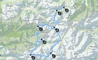
Dag 3: Untere und obere Alpschelle - E4 alpin - Gamsboden - Göppinger Hütte
Uppstigning ca 970 m, nedstigning ca 570 m, vandringstid ca 6 tim.
Dag 4: Steinmayerweg - Johannisjoch - Freiburger Höhenweg - Freiburger Hütte
Uppstigning ca 400 m, nedstigning ca 700 m, vandringstid ca 7 tim.
Dag 5: Steinernes Meer - Gehrengrat - Dalaaser Schütz - Spullersee - Ravensburger Hütte
Uppstigning ca 700 m, nedstigning ca 700 m, vandringstid ca 6 tim.
Dag 6: Stierlochsattel - Gstuät - busstransfer till Hochtannbergpass - Hochalppass - Baad
Uppstigning ca 470 m, nedstigning ca 1 380 m, vandringstid ca 7 tim; återresa till Hirschegg.
Väder, snöläge eller regionala förändringar kan göra att rutten behöver anpassas. Den planerade turen kan därför inte garanteras i varje detalj.
Participants:
6 personer, max. 11
Price per Person
965,00 €
Here you will find the terms and conditions regarding payment and cancellation
Who is this tour suitable for?
This trip is suitable for walkers with previous mountain experience, good fitness, sure-footedness and enjoyment of multi-day Alpine hiking. The daily stages are demanding enough to feel rewarding, yet very enjoyable with good preparation.
It is ideal for guests who want a classic hut-to-hut tour in Vorarlberg with professional guiding and well-established organisation.
Fitness
Ascents and descents of up to 1,400 vertical metres, with a maximum walking time of 7 to 9 hours per day, depending on the weather, trail conditions and the fitness of the group. Longer breaks are usually taken after around 1 to 2 hours of walking. For tours at altitudes above 3,000 m, prior acclimatisation is recommended.
Technical requirements
These routes are mostly demanding and tend towards difficult mountain trails. The steep, narrow paths partly lead through unmarked, boulder-strewn terrain. Exposed sections, some of which are secured with steel cables, should not be a problem for you. Depending on weather and snow conditions in the mountains, the route can become very challenging. Sure-footedness, a good head for heights and mountain walking experience are essential.
Accommodation & Meals
Accommodation
In the mountain huts, we stay in mattress dormitories or shared rooms. All huts have washrooms, and some huts also offer shower facilities. In the guesthouse or hotel, we stay in double or shared rooms with shower/WC; in some cases, shared corridor showers/WCs are used. Solo travellers are accommodated with people of the same gender. Single rooms are not available.
Meals
At the accommodation, we are well catered for with half board. Vegetarian meals are also possible; please state this when booking, no later than two weeks before the start of the tour. Along the way, there are often welcoming places to stop for refreshments, or you can arrange a packed lunch in the morning for an additional charge. It is therefore sufficient to bring enough to drink and a small snack, such as an energy bar, for the start of the tour. Your guide will advise you on the following tour days.
Included in the tour price
Certified mountain or hiking guide
4 nights half board in mountain huts, in shared rooms or dormitories
1 night half board in an inn, in a double or shared room
Transfers during the tour
Additional costs
Drinks, snacks and packed lunch provisions: approx. 45.00 € per person per day depending on personal needs
Individual tips
Travel insurance
Parking fees: 5.00 € per day
Departures in 2026
S33-26-4 12.07.2026 - 17.07.2026 with Andreas Pospischiläntalista
S33-26-5 19.07.2026 - 24.07.2026 with Alexander Hinterramskogler
S33-26-6 26.07.2026 - 31.07.2026 with Leonard Schaum
S33-26-7 02.08.2026 - 07.08.2026 with Linus Walch
S33-26-8 09.08.2026 - 14.08.2026 with Antonia Mathee (waiting list)
S33-26-9 16.08.2026 - 21.08.2026 with Marcel Löwy (waiting list)
S33-26-10 23.08.2026 - 28.08.2026
S33-26-11 30.08.2026 - 04.09.2026 with Matthias Feurstein
S33-26-12 06.09.2026 - 11.09.2026
S33-26-13 13.09.2026 - 18.09.2026
Mötesplatsen
The meeting point is at 11:00 am at Bergschule Kleinwalsertal, Walserstraße 262, 6992 Hirschegg, Austria.
Return
The return to Hirschegg is planned for around 4:00 pm on the final tour day.
Parken
With advance registration, you can park at the Bergschule Kleinwalsertal car park; the parking fee is 5.00 € per day.
Is there still some information missing? Please have a look here!
About the region
The Lechquellengebirge is a small mountain range in the northern Limestone Alps, part of the Eastern Alps. It lies entirely within the Austrian state of Vorarlberg and encompasses the upper reaches of the River Lech, with its horseshoe-shaped headwater streams, as well as the upper part of the Großwalsertal valley.
The landscape of the Lechquellengebirge is characterised by the contrast between the relatively gentle, north-east-sloping Upper Lech Valley, which drains towards the Danube, and the deep and partly steep valleys that drain towards the Rhine. The watershed runs in a horseshoe shape around the headwaters of the Lech, and the steeper gradient towards the Rhine means that (over geologically speaking relatively short periods of time) more and more streams are being claimed by the Rhine, thereby continuously shifting the watershed towards the headwaters of the Lech. A similar phenomenon occurs to the south and west of the Danube’s headwaters (via the River Wutach).
The horseshoe-shaped watershed also encompasses the highest peaks, where the summit area slopes from the south-east towards the north-west towards the Bregenzerwald. The Lech headwaters are largely undeveloped, apart from a few ski lifts and cable cars in the immediate vicinity of Lech and Zürs. Narrow toll roads lead into the valleys, and during the summer a shuttle bus runs from Lech to the Lech headwaters. On the other hand, the conditions for hikers are ideal – thanks to a network of huts linked by a high-altitude trail. This trail follows the entire horseshoe shape of the peaks, but requires, at least until the start of midsummer, some alpine experience.
The River Lech, whose name etymologically means ‘the stony one’, has its source in the Lechquellengebirge from the two headwater streams, the Formarinbach (whose source is near Formarinsee) and the Spullerbach, which flows out of Spullersee and joins the Lech. The Lechquellengebirge comprises many high peaks, the three highest of which exceed 2,700 metres: Große Wildgrubenspitze, 2,753 m; Rote Wand, 2,704 m; and Großer Grätlisgrat, 2,702 m
Downloads and further information
Detailed itinerary
Equipment list
Frequently asked questions about alpine hiking tours