Following the Adlerweg
A demanding hut-to-hut hike on the Lechtaler Höhenweg in the Lechtal Alps.
This is a tour for experienced mountain walkers: following the Adlerweg, the route leads through the Lechtal Alps, past clear mountain lakes, rugged rock, panoramic passes and small, welcoming huts. If you are sure-footed, have a head for heights and enjoy long days in the mountains, this is one of Tyrols most rewarding multi-day hikes.
Duration
6 days / 5 nights in mountain huts (sunday - friday)
A true Alpine hut-to-hut tour
 | Tourdetails and other useful information Following-the-Adlerweg-trail-EN.pdf (593.06KB) |
| Following-the-Adlerweg-trail-EN.pdf (593.06KB) |
Impressive scenery, rugged rock towers, high walls and friendly huts define this journey. The Lechtaler Höhenweg connects mountain huts at altitudes between around 2,000 and 3,000 metres and crosses one of the most striking parts of the Northern Limestone Alps.
The route follows the spirit of the Adlerweg and shows the Lechtal Alps from a wild, varied and deeply authentic side. Expect rocky terrain, green Alpine meadows, clear mountain lakes, panoramic cols and the simple atmosphere of classic mountain huts.
This is not an easy leisure walk. It is a genuine Alpine journey for guests with mountain experience who are comfortable with exposed paths and occasional easy scrambling.
Itinerary (summary)
Day 1: Boden - Pfafflar - Galtseitejoch - Hanauer Hütte
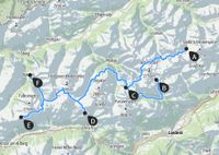
Ascent approx. 1,110 m, descent approx. 530 m, walking time approx. 5 hrs 30 mins.
Day 2: Parzinnensee - Gufelseejoch - Gufelsee - Bittrichsee - Bitterscharte - Württemberger Haus
Ascent approx. 1,060 m, descent approx. 760 m, walking time approx. 5 hrs 30 mins.
Day 3: Großbergspitze - Seescharte - Unterer Seewisee - Memminger Hütte
Ascent approx. 660 m, descent approx. 630 m, walking time approx. 4 hrs.
Day 4: Parseiertal - Grießlscharte - Ansbacher Hütte
Ascent approx. 1,100 m, descent approx. 950 m, walking time approx. 7 hrs.
Day 5: Flarschjoch - Alperschonerjoch - Hinterseejöchl - Kaiserjoch - Leutkircher Hütte
Ascent approx. 730 m, descent approx. 860 m, walking time approx. 6 hrs 30 mins.
Day 6: Bodenalp - Kaisers eller Lech; alternativ via Stuttgarter Hütte och Zürs
Standard route: ascent approx. 50 m, descent approx. 940 m, walking time approx. 3 hrs; taxi return to the starting point.
Weather, snow conditions or regional changes may require adjustments to the planned itinerary. The exact route cannot therefore be guaranteed in every detail.
Number of participants
min 6, max 8 Persons
Price per person
985,00
Please find here payment and cancellation terms
Who is this tour suitable for?
This Adlerweg tour is suitable for experienced mountain walkers with good fitness, sure-footedness and a head for heights. Steep and narrow paths, blocky terrain, exposed sections and some cable-secured passages are part of the route character.
If you have already completed multi-day mountain walks and feel comfortable on long daily stages, this tour offers an intense and varied hut-to-hut experience. If you have not yet walked in the mountains for several consecutive days, careful preparation or a shorter introductory tour is recommended.
Fitness
Ascents and descents of up to 1,400 vertical metres, with a maximum walking time of 7 to 9 hours per day, depending on the weather, trail conditions and the fitness of the group. Longer breaks are usually taken after around 1 to 2 hours of walking. For tours at altitudes above 3,000 m, prior acclimatisation is recommended.
Technical requirements
These routes are mostly demanding and tend towards difficult mountain trails. The steep, narrow paths partly lead through unmarked, boulder-strewn terrain. Exposed sections, some of which are secured with steel cables, should not be a problem for you. Depending on weather and snow conditions in the mountains, the route can become very challenging. Sure-footedness, a good head for heights and mountain walking experience are essential.
This is included in the price of the trip
State-certified mountain or hiking guide
5 nights’ accommodation with half-board in cottages (shared rooms or dormitories)
Return transport
Additional costs
Drinks, snacks and provisions for your rucksack: Cash – approx. €45.00 per person per day, depending on personal requirements
Individual tips
Travel insurance
Car park charges
Accommodation & Meals
Accommodation
In the mountain huts, we stay in mattress dormitories or shared rooms. All huts have washrooms, and some huts also offer shower facilities.
Meals
At the accommodation, we are well catered for with half board. Vegetarian meals are also possible; please state this when booking, no later than two weeks before the start of the tour. Along the way, there are often welcoming places to stop for refreshments, or you can arrange a packed lunch in the morning for an additional charge. It is therefore sufficient to bring enough to drink and a small snack, such as an energy bar, for the start of the tour. Your guide will advise you on the following tour days.
Departures 2026
S109-26-4 09.08.2026 - 14.08.2026 with Edi Radeticchio (vänta lista)
S109-26-5 23.08.2026 - 28.08.2026 with Brian Kennedy
S109-26-6 06.09.2026 - 11.09.2026 with Wolfi Schmid
Meeting point
10:00 Uhr Parkplatz Hanauer Hütte, Boden, Österrike
The starting point is Boden in the Lechtal valley, which can be reached by car or public transport. For rail travel, Reutte and Füssen are useful nearby stations; international rail connections are available via Imst, Garmisch, Innsbruck and Munich.
Retur
Cirka 1 pm on the last day
Parking
Parking is available near the Hanauer Hut in Boden. The source document mentions a voluntary parking fee of 3.00 euros per day. On the final tour day, a taxi brings the group back to the starting point.
Is there any information missing? Please have a look at our FAQs!
About the region
The Lechtal is an Alpine valley in Austria, the majority of which lies in Tyrol, with smaller parts in Vorarlberg and Bavaria. The River Lech flows through the valley. Geographically, it is bounded to the south by the Lechtal Alps and to the north by the Allgäu Alps, and its headwaters are in the Lechquellengebirge. The Tyrolean Lechtal holiday region lies nestled between the Lechtal and Allgäu Alps. A few years ago, the Lech’s unspoilt natural environment was the reason why the river was placed under protection. The area, originally designated as a Natura 2000 site, was subsequently declared a nature park. Today, it covers an area of 42.38 km² in the heart of the Lechtal region.
The Lechtal Alps are a mountain range with a distinct main ridge and long, extensively branched side ridges. It is approximately 70 km long and 20 km wide on average. The area is characterised by a diverse, often locally varying rock composition consisting mainly of sedimentary rocks, which gives rise to a highly varied landscape. The most important rock-forming material is the main dolomite, which gives rise to often brittle, heavily fractured and rocky mountains (e.g. Dremelspitze, Leiterspitze, Vorderseespitze, Vallesinspitze). Equally significant is the Fleckenmergel, with its yellowish, brittle scree slopes at higher altitudes (e.g. at Parseierspitze, Trittkopf, Freispitze) and its flower-rich, dense green meadows at medium altitudes. Aptychenkalk gives rise to sharp ridges (the summit crown of Parseierspitze, Roggspitze) . Oberrätkalk (e.g. Holzgauer Wetterspitze, Freispitze) offers a very hard, light-coloured limestone with excellent climbing opportunities. Wettersteinkalk forms the long Heiterwand face and is characterised by a compact, relatively uniform appearance with impressive rock faces.
The Lechtaler Höhenweg follows the main ridge of the Lechtaler Alps over a distance of around 100 kilometres at an altitude of between 2,000 and 2,500 metres. It forms part of the North Alpine Long-Distance Trail 01 and the European Long-Distance Trail E4. Like pearls on a necklace, 13 Alpine Club huts are strung along the trail. These well-equipped huts offer excellent service to the many hikers.
Downloads and further information
detailed description of the trip
packing list
Frequently asked questions